Where to fish

  • Forecast
  • Catches

Mine

  • Favorites

Where to fish

  • Forecast
  • Catches

Mine

  • Favorites
ForecastCatchesFavorites
AboutHow the forecast worksWhere fish livePrivacyTerms[email protected]
© 2026·AI-powered bite forecast
0.1.0+2163 · 92c14a40

We use cookies for analytics and advertising. Cookies necessary for the site to function are always kept. Learn more

United States / Delaware / Indian River Bay

Bite forecast: Indian River Bay

Loading map…

Best fishing days for the next week

  1. TuesdaySeptember 8weather-based forecast
    57/100medium activity

    Cloudy: 63–82 °F

  2. ThursdaySeptember 3weather-based forecast
    51/100medium activity

    Drizzle: 73–82 °F

  3. FridaySeptember 4weather-based forecast
    48/100medium activity

    Clear: 73–86 °F

Indian River Bay (Delaware) — a popular fishing spot. This is a sea water — its bite forecast is a marine one, computed apart from rivers and lakes. Here you'll find a bite prediction — when fish are active and which hours give the best chances, adjusted for weather and pressure.

Loading map…

Catches

Recorded 1 catch here. Most commonly caught: Striped bass. Peak season: November.
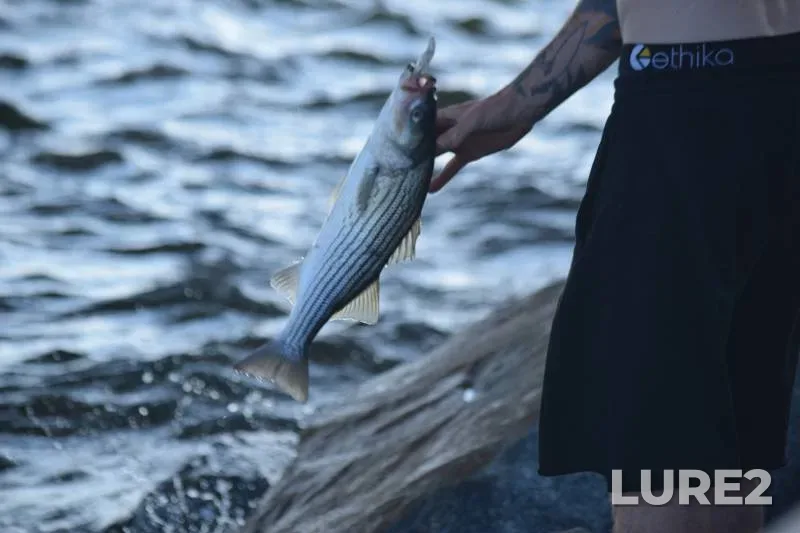
  • Striped bass — Indian River Bay, Nov 12, 2017
    Striped bass
    Indian River Bay
    46 °F2 mph
    Nov 12, 2017

Bite calendar

7–Sep 13
Mon
Tue
Wed
Thu
Fri
Sat
Sun
Bite activity:highmediumlowslow
Based on:weatherseasonal
What is a bite calendar?
FlounderRed drumStriped bassBluefishBlack drumSpanish mackerelSpotted seatrout

Black drum

6/10 · Fair

Hourly activity

0:006:0012:0018:0023:00
Bite activity:highmediumlow

The bite is moderate — fish feed in short bursts. Pressure is rising — activity tends to be more subdued.

Peak bite hours

Best time — 00:00–04:00 and 22:00–23:00 (nighttime activity).

Tactics

Look for structure — reefs, flats, channel edges; work them slowly near the bottom.

Lures

In clear water, natural colors work best: soft-plastic jig or live bait.

Gear

It's a hot day — a hat, sunglasses, and plenty of water are a must.

Summary

An average day — best chances during peak windows.

How this forecast is calculated

Why this forecast

The computed water temperature is around 73 °F — inside the 61–79 °F comfort range for Black drum, so baseline activity is high.

Computed water temperature by month; the green band is the 61–79 °F comfort rangecomfort 61–79 °F73 °F
JFMAMJJASOND

Black drum feeds at night: the peak falls in the dark hours, between sunset and sunrise.

The day: daylight hours and when Black drum feeds0:0012:0024:00

Pressure is rising 0.09 inHg over the day — the bite usually settles down after a rise.

Pressure through the day, 0.09 inHg change
00:00 · 30.1023:00 · 30.20 inHg

One more input — the moon's feeding windows: within their hours the score sits higher than across the rest of the day. The window times are in the “Solunar feeding periods” card below.

Feeding windows on the day scale0:0012:0024:00

September is an active season for Black drum here.

JFMAMJJASOND

These are the same values the bite curve above was computed from. How the forecast works

Tides

  • High water04:140.1 ft
  • Low water10:19-3.1 ft
  • High water17:051.0 ft
0:006:0012:0018:0023:000:006:0012:0018:0023:00
Sea level height by hour
00:0001:0002:0003:0004:0005:0006:0007:0008:0009:0010:0011:0012:0013:0014:0015:0016:0017:0018:0019:0020:0021:0022:0023:00
-2.1 ft-1.5 ft-0.8 ft-0.1 ft0.1 ft0.0 ft-0.3 ft-1.0 ft-1.8 ft-2.7 ft-3.1 ft-3.0 ft-2.6 ft-1.9 ft-1.0 ft0.1 ft0.8 ft1.0 ft0.8 ft0.3 ft-0.7 ft-1.8 ft-2.7 ft-3.1 ft

Open-Meteo tide model, grid point 7.2 mi away

Water

Water temp.
77 °F
In the model
73 °F
Wave
2.4 ft
Period
7 s

Open-Meteo Marine model, grid cell 7.2 mi from the waterbody. Values are daily means.

7 SepMonday, September 7
+75°

Clear · feels like +75°

Low / high
+61°…+79°
Precipitation
0.00 in
Wind
7 mph NNW
Cloud cover
1%
Humidity
45%
Pressure
30.18 inHg
00:00+65°—1 mphnorthwest wind, 1 mph78%0%
01:00+64°—3 mphnorthwest wind, 3 mph82%0%
02:00+64°—4 mphnorthwest wind, 4 mph84%0%
03:00+62°—6 mphwest wind, 6 mph88%0%
04:00+62°—7 mphnorthwest wind, 7 mph90%0%
05:00+61°—8 mphnorthwest wind, 8 mph91%0%
06:00+61°—8 mphnorthwest wind, 8 mph90%0%
07:00+61°—7 mphnorthwest wind, 7 mph86%0%
08:00+64°—6 mphnorth wind, 6 mph76%0%
09:00+67°—6 mphnorth wind, 6 mph68%0%
10:00+70°—7 mphnorth wind, 7 mph58%0%
11:00+73°—7 mphnorth wind, 7 mph50%0%
12:00+75°—7 mphnorth wind, 7 mph45%1%
13:00+77°—6 mphnorth wind, 6 mph41%1%
14:00+78°—6 mphnorth wind, 6 mph38%2%
15:00+79°—5 mphnorth wind, 5 mph36%2%
16:00+79°—5 mphnorth wind, 5 mph34%2%
17:00+79°—4 mphnorth wind, 4 mph35%2%
18:00+76°—2 mphnorthwest wind, 2 mph38%1%
19:00+73°—4 mphsouthwest wind, 4 mph43%0%
20:00+70°—7 mphsouthwest wind, 7 mph48%0%
21:00+68°—8 mphsouthwest wind, 8 mph55%5%
22:00+66°—8 mphsouthwest wind, 8 mph62%14%
23:00+65°—8 mphsouth wind, 8 mph68%21%
+79°+70°+61°
Weather throughout the day
0:006:0012:0018:0023:00

Sun and moon

Monday, September 7
The day: daylight and the hours the moon is above the horizon. Local time0:0012:0024:00
DaylightMoon above the horizon
Sunrise
06:35
Sunset
19:23
Day length
12 h 48 min
Sunshine hours
12 h
UV index
6
high
Moon
Waning crescent
Moonrise
02:13
Moonset
17:29

The day is 2 min shorter than yesterday.

Sunshine hours count direct sun only — cloud cover cuts it, so it is shorter than daylight.

Solunar feeding periods

+13% in the windowMonday, September 7
Feeding windows on the day scale, local time0:0012:0024:00
Major periodsMinor periods
  • Minor01:43–02:43Moonrise
  • Major08:57–10:57Moon overhead
  • Minor16:59–17:59Moonset
  • Major21:25–23:25Moon underfoot

The windows are set by the moon's transit and rise, and the forecast above already accounts for them: within these hours the bite score sits higher than across the rest of the day, while the day's overall level still comes from the catch-calibrated model.

What are solunar periods?

Nearby rivers

  • Indian River Bay1 mi
  • Rehoboth Bay4 mi
  • White Creek4 mi

Nearby water bodies

  • BayIndian River Bay0 mi
  • BayIndian River Bay0.4 mi
  • BayIndian River Bay0.4 mi
  • LakeSawpit Cove0.7 mi
  • BayIndian River Bay1 mi
  • BayIndian River Bay1 mi
  • BayRehoboth Bay1 mi
  • BayRehoboth Bay1 mi
  • BayIndian River Bay2 mi
  • BayIndian River Bay2 mi

Measured river conditions are available for Indian River Bay: current gauge height, streamflow, and water temperature when reported by the source.

Water

Gauge height
2.73 ft

USGS gauge INDIAN RIVER BAY INLET NEAR BETHANY BEACH, DE, 1 mi away · measured 2014-10-01 00:54 · data source · provisional data, subject to revision